
Monday, December 17, 2012
Pannonian mixed forests (12)

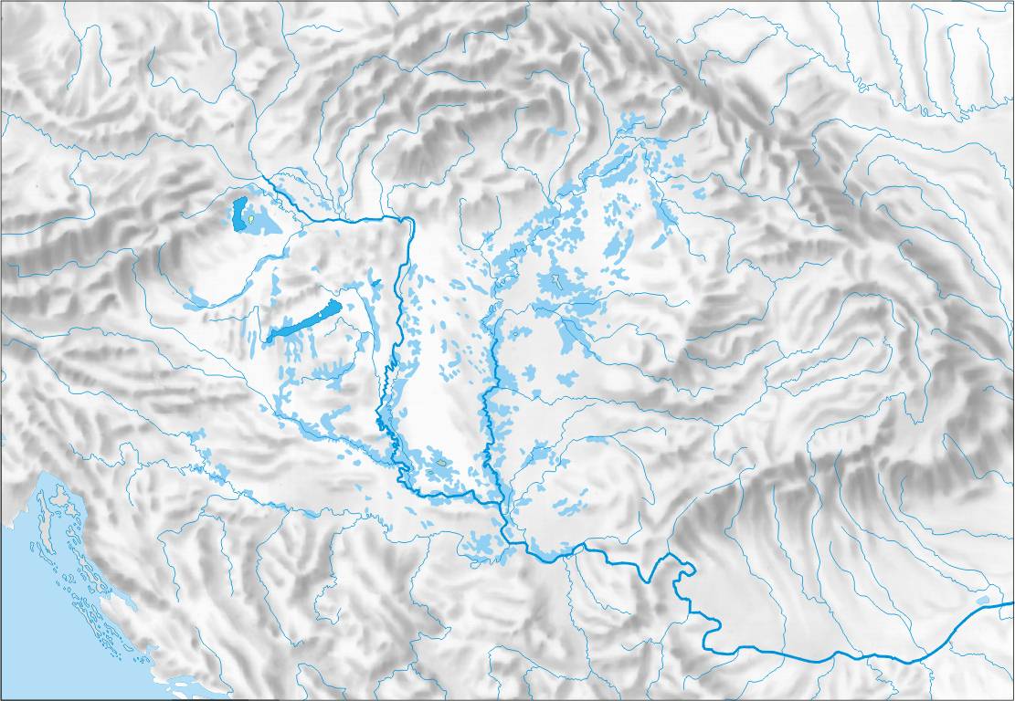
Carpathian Basin (13)
UNDER CONSTRUCTION
The Carpathian (Pannonian) Basin comprises a topographically discrete lowland region extending across a wide range of modern political boundaries in the southeastern part of Central Europe (roughly between Vienna in the northwest, Zagreb in the southwest, Belgrade in the southeast and Satu Mare in the northeast). Its geographic boundaries are set by the Carpathian Mountains, the Alps, the Dinarides and the Balkan mountains. The rivers Danube and Tisza divide the basin roughly in half. Most of the area consists of the Great Hungarian Plain and Eastern Slovak Lowland in the south and east, and (divided by the Transdanubian Mountains) the Little Hungarian Plain in the northwest.
The highest range within the Carpathians are the Tatras, on the border of Poland and Slovakia, where the highest peaks slightly exceed 2600 meters elevation. The entire Carpathian chain is usually divided into three major parts: the Western Carpathians (Czech Republic, Poland, Slovakia, Hungary), the Eastern Carpathians (SE Poland, eastern Slovakia, Ukraine, Romania), and the Southern Carpathians (Romania).
 |
| Relief map of Carpathian basin |
http://www.eoearth.org/article/Ecoregions_of_Romania?topic=49597
http://www.eoearth.org/article/Ecoregions_of_Bulgaria
Sunday, December 16, 2012
Balkan Mixed Forest Zone (14)
 |
| Balkan mixed forest zone |
To the south it merges with the Mediterranean ecological zones, while to the north and east with the
Pannonian mixed forests (in Bosnia and Herzegovina, Serbia and Romania), Carpathian montane conifer forests, Central European mixed forests (both in Romania), as well as the East European forest steppe and Pontic steppe (both situated in Romania and Bulgaria).
Several species of deciduous oaks (most prominently Quercus frainetto, as well as Q. cerris, Q. pubescens) dominate most of the ecoregion's forests, interspersed higher up mountainsides (above 800–1200 m) mostly with European Beech and such conifers as Scots Pine, Macedonian Pine, Silver Fir and Norway Spruce. The highest peaks support alpine tundra vegetation.
 |
| Taukliman salt lake on the Bulgarian Black Sea coast |
The mountains of the balkan region have their own ecological zones, such as the higher parts of the Rhodope and Balkan Mountains, which form their own ecological zone, the Rodope montane mixed forests, or the Pindus Mountains mixed forests (in Greece, the Republic of Macedonia and Albania).
"Balkan mixed forests". Terrestrial Ecoregions. World Wildlife Fund.
Saturday, December 15, 2012
Dinaric Mountain Vegetation Zone (15)
Like the rest of the Mediterranean zone, as defined by the World Wildlife Fund, this mountainous region with a wide altitudinal range is characterized by hot, dry summers and mild to cool rainy winters. With high precipitation ranges and an overabundance of limestones, karst relief is a dominating landform. The region is home to a large diversity of habitats and species such as the Pindus Mountains mixed forests (in Greece, the Republic of Macedonia and Albania), Dinaric Mountains mixed forests (in Montenegro and Bosnia and Herzegovina). Within the zone, the various vegetation groups form a mosaic of forests, woodlands, savannas, shrublands, and grasslands forming complex landscape patterns created by variations in soil, topography, exposure to wind and sun, and fire history. The lower altitude forests (below 600–1000 m) are of mixed broadleaf composition - dominant species include various deciduous oaks (Quercus frainetto, Q. pubescens, Q. cerris), Carpinus orientalis. Fraxinus ornus marks the submediterranean zone. The highest elevations (above 1,500 m) are covered with conifer forests,
The conifer zone is dominated by the Norway Spruce, Silver Fir and European Black Pine with the admixture of the European Beech. The region is also characterised by a wide variety of sclerophyll shrubs as in the mediterranean ecological zone.
Mediterranean Forests, Woodlands, and Scrub Ecoregions". Terrestrial Ecoregions. World Wildlife Fund.
Dinaric Mountains mixed forests". Terrestrial Ecoregions. World Wildlife Fund.
Friday, December 14, 2012
Mediterranean Ecological Zone (16)
The Mediterranean zone in Europe, North Africa, and Asia Minor (around the Mediterranean Sea) is characterized by hot, dry summers and mild to cool rainy winters. The region, as defined by the World Wildlife Fund, contains a large diversity of habitats and species such as the Pindus Mountains mixed forests (in Greece, the Republic of Macedonia and Albania), Dinaric Mountains mixed forests (in Montenegro and Bosnia and Herzegovina). Vegetation types can range from forests to woodlands, savannas, shrublands, and grasslands; "mosaic habitat" landscapes are common, where differing vegetation types are interleaved with one another in complex patterns created by variations in soil, topography, exposure to wind and sun, and fire history.
Mediterranean shrublands have flora that are significantly more diverse than the other ecoregions relative to other non-forest ecoregions. The Mediterranean biome is characterized by shrubs. In most regions these shrubs are evergreen and have small, leathery (sclerophyllous) leaves with thick cuticles to retain moisture in the dry summer months. Sometimes the leaves are so reduced as to appear needle-like. Many typical members of the shrub flora are aromatic (for example, sage, rosemary, thyme, and oregano) and contain highly flammable oils.
Mediterranean regions have long been impacted by humans especially through the use of fire and the grazing of livestock. We know from classical Greek literature that the area was formerly forested with live oaks, pines, cedars, wild carob and wild olive. Much of the formation is considered a subclimax developed on degraded and eroded soils and maintained in part by fire and goats.

Mediterranean Forests, Woodlands, and Scrub Ecoregions". WWF.
Further to the west are the Dinaric Mountains mixed forests (in Montenegro and Bosnia and Herzegovina),
Sunday, December 9, 2012
Environmental Zones of Europe: An Alternative Scheme
The EBONE (European Biodiversity Observation Network) website defines what it calls the Environmental Zones of Europe, which it derives from smaller units, the European Environmental Stratification (ref. Metzger et al 2005 and Jongman et al 2005, n.v.). The latter is based on climate data, data on the ocean influence and geographical position (northing). It does not consider soil data, because it claims they are not distinctive at the level of Europe, as the soil classification systems differ for each country. Eighty four strata have been classified and these are aggregated into thirteen major Environmental Zones (EnZs) to facilitate communication. The EnZ are based on statistical procedures.

While they have a close relationship to the Biogeographical zones of Europe, they are not completely the same as the latter. The zones that have been derived are:
Alpine North: Scandinavian mountains; these have been named Alpine north, because they show environmental conditions as the Alps on a higher latitude, but in lower mountains.It can be seen that the main region occupied by the Early Medieval Slavs was the Continental (CON) environmental zone, on the plains and lowlands of Central and Eastern Europe and uplands and low mountains of the Balkan peninsula. There was an expansion of Slavic-speaking communities down south into the Pannonic-Pontic (PAN) region at the beginning of the European migration period. The nemoral zone (NEM) of the north-west of the Russian Plain was also an area of later expansion. The authors characterize these areas as follows (details of geology omitted):
Alpine South: the high mountains of central and southern Europe that show the environmental conditions of high mountains. Unlike the Biogeographical zonation of Europe as presented by the EEA (http://www.eea.eu.int) here also small Alpine patches are found in mountain areas outside the Alps Pyrenees and Carpathians.
Atlantic Central is the area with moderate climate where the average winter temperature does not go far below 0°C and the average summer temperatures are relatively low.
Atlantic North: is the area under influence of the Atlantic ocean and the North sea, humid with rather low temperatures in summer and winter, but not extremely cold.Boreal: is the environmental zone covering the lowlands of Scandinavia, mainly characterised by Conifer forests.
Continental: is the part of Europe with an environment of warm summers and rather cold winters and where Beech is a dominant tree species
Lusitenean: is the southern Atlantic area from western France to Lisbon. Here the summer temperatures are rather high and there are some dry months occur, winters are mild and humid. It is the region of the southern European heathlands and the Pyrenean oak.
Mediterranean Mountains: these mountains are influenced by both the Mediterranean zone they are situated in, nbut still they show an influence of mountain climate. This is the area where Mediterranean Beech forests are found
Mediterrenean North: the Mediteranean northern represents the major part of the Mediterranean climate zone with Holm oak, Cork Oak many fruit plantations and Olive groves.Mediterrenean South: this zone represents the extreme Mediterranean climate that is shared with northern Africa, short precipitation periods and long hot, dry summers.
Nemoral: the zone covering the southern part of Scandinavia, the Baltic states and Belarus. It is the environmental zone characterised by mixtures of Taiga forest and Deciduous broadleaved forests.
Pannonian-Pontic: this is the most steppic part of Europe, with cold winters and dry hot summers. Most precipitation falls in spring . Obne of the characteristic plant species is Stipa ssp.
Anatolian: represents the steppes of Turkey, a Mediterranean steppic environment. It is not included in the PAN database as there is no representation from Turkey yet.
The Continental Environmental zone:
The climate is continental, with clear summer maximum of precipitations and 15-20° difference in the average monthly temperatures. The growing season lasts 227 (213-257) days, the sum of active temperatures is 3294° C (3037°- 3049°). The highest values are reached in the continental parts of the Balkan peninsula. [...] The potential vegetation consists of deciduous forests in the west, mixed and coniferous forests in the central area. It is the central area of the distribution of Beech (Fagus sylvatica) and characterized by a variety in beech forest types. The soil is rich and fertile, This means that most of the area are agricultural lands used for crop production. In the hills and mountains forestry dominates. In the eastern part of Poland and in Belarus larger remnants of natural forest still exist.
The Pannonian Environmental zone
occupies lowlands, valleys and mountain peripheries on the Middle- and the Lower-Danube Plains and the Black-Sea lowland. [...] This zone is characteristic for the flat relief, dry continental climate (maximum of precipitations in summer, the yearly amplitude of temperature is 20°) and steppe-like natural vegetation. The formations dominated by trees grow only along the rivers (willow, black poplar) and in the mountain peripheries (oak). The growing season lasts 250 days (245-252), the sum of temperatures above +10° is 4099°C (3831°- 4361°). [...] The potential natural vegetation is dominated by mixed Acer and Turkish oak forests as well as steppe vegetation (Stipa sp. grasslands). Therefore, historically the area the area is dominated by grassland farming; nowadays many areas are converted into crops.The Nemoral environmental zone:
The growing season lasts in average 196 days (190-204), the sum of temperatures above +10° is in average 2717°C (2561°-2898 °). This is rather low. The most characteristic in the Nemoral zone are well developed forms of glacial accumulation (moraine and fluvioglacial) and mixed and evergreen coniferous forests. [...] The land cover of this zone is Taiga forest wetlands and bogs. Most of the natural forests have been converted into agricultural lands or into production forests (in particular in Scandinavia). The main arable crops are barley and wheat. Bogs and large floodplain marshes are very common.The agricultural use is dominated by dairy farming and cattle farming. Forestry is an important form of land use.There is a slightly more simplified (but through that more legible) example of another map showing a similar - but not identical - pattern in Wikicommons (click here for larger format).
 |
| Map of the biogeographic regions of Europe, after EEA's map (Júlio Reis after European Environment Agency). |
Jongman R.H.G., Bunce R.G.H., Metzger M.J., Mücher C.A. Howard D.C. & Mateus V.L. (2006) Objectives and applications of a statistical Environmental stratification of Europe. Landscape Ecoogy 21: 409-419. DOI link: http://dx.doi.org/10.1007/s10980-005-6428-0
Metzger M.J., Bunce R.G.H, Jongman R.H.G, Mücher C.A. & Watkins J.W. (2005). A climatic stratification of the environment of Europe. Global Ecology and Biogeography 14: 549-563. DOI link: http://dx.doi.org/10.1111/j.1466-822x.2005.00190.x
Saturday, December 1, 2012




Subscribe to:
Posts (Atom)