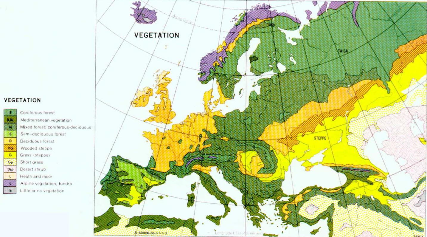
- Vegetation Zones of Central and Eastern Europe (1)...
- Russian Taiga (2)
- Sarmatic Mixed Forests (3)
- Baltic Mixed Forests (4)
- Western European Broadleaf Forests (5)
- Central European Mixed Forests (6)
- Białowieza Forest (6a)
- East European Forest Steppe (7)
- Pripet Marshes (8)
- The Steppes (9)
- Carpathian Montane Forests (10)
- Alpine vegetation zone (11)
- Pannonian mixed forests (12)
- Carpathian Basin (13)
- Balkan Mixed Forest Zone (14)
- Dinaric Mountain Vegetation Zone (15)
- Mediterranean Ecological Zone (16)
- Environmental Zones of Europe: An Alternative Sche...
Friday, December 28, 2012
Key to regional posts
Thursday, December 27, 2012
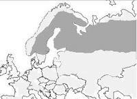
Vegetation Zones of Central and Eastern Europe (1)
.
The names and extents of these zones tends to vary from map to map. This is the centre cut from a more extensive map which seems pretty clear. The Taiga runs across the top of the map, then there is a broad band of coniferous-mixed forest (except on the mountain slopes which have patches of mainly coniferous forest). On the edges of this, bordering the forest steppe (including in the carpathian basin) and in western Europe is a more deciduous forest. Right down the south, areas settled by the Slavs the dominant vegetation type is 'Mediterranean'.
 |
| http://www.civfanatics.net/uploads/europe_nv.jpg |
 |
| http://www.civfanatics.net/uploads/europe_nv.jpg |
Russian Taiga (2)
.
 The taiga (the name is Russian for 'forest') was not settled to any
extent by the Slavic-speaking communities until East Slavs penetrated
the fringes of the zone (in the vicinity of Lakes Ladoga and Onega and
the shores of the Gulf of Finland) some time before the 11th century AD.
Another name for the ecozone is the Boreal coniferous forest, and it
lies just south of the tundra. The winters in the taiga are very cold
with only snowfall, while the summers are warm, rainy, and humid, though
also very short with about 50 to 100 frost free days. The dominant species are coniferous trees, especially species of fir, larch, pine, and
spruce (though some broad-leaved angiosperm species, especially aspen,
birch, poplar, and willow also grow). The area is susceptible to
wildfires and insect damage which may lead to deforestation of large
areas. The fauna includes beaver, red squirrels and voles, red deer and elk can
be found in regions of the taiga where more deciduous trees grow. There
are also quite a few predators such as the lynx and mustelids such as wolverines, minks and ermine. Several of these species were valued in Early Medieval times for their furs.
The taiga (the name is Russian for 'forest') was not settled to any
extent by the Slavic-speaking communities until East Slavs penetrated
the fringes of the zone (in the vicinity of Lakes Ladoga and Onega and
the shores of the Gulf of Finland) some time before the 11th century AD.
Another name for the ecozone is the Boreal coniferous forest, and it
lies just south of the tundra. The winters in the taiga are very cold
with only snowfall, while the summers are warm, rainy, and humid, though
also very short with about 50 to 100 frost free days. The dominant species are coniferous trees, especially species of fir, larch, pine, and
spruce (though some broad-leaved angiosperm species, especially aspen,
birch, poplar, and willow also grow). The area is susceptible to
wildfires and insect damage which may lead to deforestation of large
areas. The fauna includes beaver, red squirrels and voles, red deer and elk can
be found in regions of the taiga where more deciduous trees grow. There
are also quite a few predators such as the lynx and mustelids such as wolverines, minks and ermine. Several of these species were valued in Early Medieval times for their furs.
And a few photos to remind us why the area was not particularly inviting for settlement. These three photos from the villa.ru website, taken in the St Petersburg region in winter.


There are some wonderful photos of the ecosystems of the region on the www.ecosystema.ru
website the first five used on this page were taken by Anatoly
I. Haritonov.
 |
| Mixed forest. Ladoga Province of taiga, Nizhnesvirsky Reserve, Leningrad Region- |
 |
| Mature pine (light-coniferous) blueberry forest with Ledum. South Karelia |
 |
| The Dolgaya river - a tributary of the river Luga.
Ladoga Province of taiga, Nizhnesvirsky Reserve, Leningrad Region |
 |
| Waterlogged dark coniferous (spruce) forest. Ladoga Province of taiga, Nizhnesvirsky Reserve, Leningrad Region |
 |
| Steep bank of Lake Ladoga. Ladoga
Province of taiga, Nizhnesvirsky Reserve, Leningrad Region |
 |
| Winter landscape |
 |
| winter landscape |

Winter sunshine near St Petersburg
See also: www.rusnature.info Biomes and Regions of Northern Eurasia: Boreal Forests.
Wednesday, December 26, 2012
Sarmatic Mixed Forests (3)
The name 'Sarmatic Mixed Forests' is used in the World Wide Fund for Nature classification (ecoregion PA0436) for a European ecoregion extending over a sizable portion of northern Europe and the Ural area of Russia: "between boreal forests/taiga in the north and the broadleaf belt in the south [...] in southernmost Norway, southern Sweden, southwesternmost Finland, Estonia, Latvia, northern Lithuania, northern Belarus and the central part of European Russia". It extends to the Urals in the east and borders on the forest steppe on the south, and is treated as separate from the Central European mixed forests. The ecoregion is abundant in surface water resources, with more than ten thousand lakes and 20,000 rivers and streams, this leads to the creation of boggy forests, that are particularly rich in wetland plants on the forest floor.
 |
| Sarmatic mixed forests stretch from southern Norway to the Ural Mountains. Source: World Wildlife Fund |
Typically, Sarmatic mixed forests comprise a transition into boreal taiga at their northern limit and mixed broadleaf forests at their southern limit. They are comprised of a mixed conifer broadleaf plant association dominated by Norway Spruce (Picea abies - which disappears further south due to insufficient moisture) and Scots Pine (pinus sylvestris - in drier locations) with some broadleaf admixture, especially oak species such as Quercus robur in the north. Toward the southern limits of the ecoregion is a conspicuous increase in broadleaf tree species including birch, beech, aspen, ash, aspen and oak. There are also a number of shrubs, wildflowers, grasses and mosses that inhabit the mid-tier and forest floor. Common low-growing shrubs include Bilberry (Vaccinium myrtillus) and Heather (Calluna vulgaris).
It is interesting to note that the name refers to a passage in the Germania of Tacitus.
Source:
C Michael Hogan (Lead Author);Sidney Draggan Ph.D. (Topic Editor) "Sarmatic mixed forests". In: Encyclopedia of Earth. Eds. Cutler J. Cleveland (Washington, D.C.: Environmental Information Coalition, National Council for Science and the Environment). December 3, 2010.
Globalspecies.org Google map
Monday, December 24, 2012
Baltic Mixed Forests (4)

The Baltic mixed forests consist of temperate broadleaf and mixed forests in northwestern continental Europe across a region stretching from Denmark eastward across northern Germany (to the north of the Elbe River), and in Poland, north of the Oder River. This ecoregion encompasses many different habitats. The dominant vegetation type is submontane beech and mixed beech forest. The other trees which may be present include oak, ash (Fraxinus excelsior) and sycamore maple (Acer pseudoplatanus)
 |
| Buchenwald forest |
 |
|
UNESCO World Heritage sites - Ancient Beech forests in Brandenburg, Hesse, Mecklenburg-Western Pomerania and Thuringia |
Map of Baltic Mixed Forest location (globalspecies.org)
Hogan, C and Draggan, P.D., "Baltic mixed forests". In: Encyclopedia of Earth. Eds. Cutler J. Cleveland (Washington, D.C.: Environmental Information Coalition, National Council for Science and the Environment).
Sunday, December 23, 2012
Western European Broadleaf Forests (5)
.
There are a few patches of Western European broadleaf forest ecosystems on the western fringes of the areas occupied by the Early Medieval Slavic-speaking communities, in Austria, Czech Republic (Bohemian Massif), western Germany (Central German Uplands, Bavarian Plateau) and adjacent areas. It is essentially composed of lowland and alti-montane beech and mixed beech forests It also includes small areas of sub-Mediterranean and meso-supra-Mediterranean downy oak forests and mixed oak hornbeam forests. This ecoregion hosts a good variety of animal species, birds in particular, and formerly a range of larger mammals.
Globalspecies.org Google map of the western European Broadleaf forests
Globalspecies.org Google map of the western European Broadleaf forests
There are a few patches of Western European broadleaf forest ecosystems on the western fringes of the areas occupied by the Early Medieval Slavic-speaking communities, in Austria, Czech Republic (Bohemian Massif), western Germany (Central German Uplands, Bavarian Plateau) and adjacent areas. It is essentially composed of lowland and alti-montane beech and mixed beech forests It also includes small areas of sub-Mediterranean and meso-supra-Mediterranean downy oak forests and mixed oak hornbeam forests. This ecoregion hosts a good variety of animal species, birds in particular, and formerly a range of larger mammals.
 |
| Beech forest, Vtáčnik, Slovakia (Wikipedia) |
 |
| Broadleaf forest (naturepl.com) |
 |
| Map of distribution of W. European Broadleaf Forest (Encyclopedia of the Earth) |
Globalspecies.org Google map of the western European Broadleaf forests
Saturday, December 22, 2012
Central European Mixed Forests (6)
.
The Central European mixed forest ecoregion, on the lowland plains of northern Europe, is the main zone within which the Early Medieval Slavic-speaking communities will have spread. It extends from eastern Germany to northern Moldova and northeastern Romania. The ecoregion thus covers large portions of Poland, Lithuania, Belarus, and Ukraine, as well as a portion of the Czech Republic. It is bordered by the lowland-colline subcontinental meadow steppes and dry grassland vegetation on the eastern side, hemiboreal spruce and pine-spruce forests to the north, beech and mixed beech forests of the Carpathians to the south, and the beech and mixed beech forests of the Baltic and Western Europe to the west.
This area was strongly affected by the Pleistocene glaciations (the
largest ice sheet advanced as far south as 47°N) the flora and fauna became impoverished as a result of repeated glaciations.
After the last ice sheet retreated about 10 000 years BP, mixed and deciduous forests became re-established on the
cover of glacial, fluvioglacial, and
glacio-lacustrine deposits left by the glaciations across the plain. The proportion of
loamy deposits gradually
increases southward and loess is typical of the southern areas. These
more loamy substrata developed stands of deciduous trees, while the
sandy and silty deposits generally supported pine and mixed stands. In
the west of the region, brown forest soils developed in the regions
dominated by Beech. In areas with a more continental climate, grey
forest soils developed, usually under oak and lime forests. Under the
mixed forests however podsols developed. With the climatic changes of
the postglacial period there were considerable changes in
flora and fauna.
The climax vegetation today is dominated by a complex mosaic of dynamic mixtures of coniferous and deciduous tree stands, consisting of lowland to submontane acidophilous oak and mixed oak forests, mixed oak-hornbeam forests, as well as lowland to submontane hemiboreal and nemoral pine forests on the North European glaciated plain. Among coniferous tree species, Picea abies and P. obovata prevail on loamy substrata and Pinus sylvestris on sandy substrata. Among deciduous species, Fagus sylvestris and Carpinus betulus are typical of the western regions and Quercus robur and Tilia cordata of the centre and the east. Today, much of the ecoregion has been cleared for agriculture, plantations and urban areas. The whole ecoregion belongs to the most densely populated and altered parts of Europe. Much of the original forest vegetation was long ago transformed into arable fields, meadows, and pastures.The percentage of forested area as well as the current forest composition varies among countries of the region, the mean forest cover in the entire region is now below 30%, and most of that is either secondary forest or forest plantations.
According to the Encyclopedia of the Earth:
The makeup of the forst is probably a little different from that of the past, today Scots pine (Pinus sylvestris) is now the most common forest tree species of the ecoregion (up to 90% in western Poland for example), but in the past it was confined to less productive habitats, primarily sandy soils in areas of low precipitation, but has spread throughout the region, even into more fertile habitats, due to extensive 19th and 20th century planting.
Despite the extensive post-Medieval clearance, semi-natural habitats (like extensively used meadows and traditional pastures) still support important plant and animal communities that include many of the original faunal inhabitants. That diversity is now largely threatened by the changes in land use pattern, namely by more intense management in some areas, and abandonment of traditional management (associated with secondary succession) in others. The forest cover in the entire region is now slowly increasing at the expense of arable land.
Source:World Wildlife Fund, 'Central European mixed forests', August 23, 2008
See also: Mixed and Deciduous Forests of the East European Plain
The Central European mixed forest ecoregion, on the lowland plains of northern Europe, is the main zone within which the Early Medieval Slavic-speaking communities will have spread. It extends from eastern Germany to northern Moldova and northeastern Romania. The ecoregion thus covers large portions of Poland, Lithuania, Belarus, and Ukraine, as well as a portion of the Czech Republic. It is bordered by the lowland-colline subcontinental meadow steppes and dry grassland vegetation on the eastern side, hemiboreal spruce and pine-spruce forests to the north, beech and mixed beech forests of the Carpathians to the south, and the beech and mixed beech forests of the Baltic and Western Europe to the west.
 |
Current extent of Central European mixed forests (after the Encyclopedia of the Earth) |
The climax vegetation today is dominated by a complex mosaic of dynamic mixtures of coniferous and deciduous tree stands, consisting of lowland to submontane acidophilous oak and mixed oak forests, mixed oak-hornbeam forests, as well as lowland to submontane hemiboreal and nemoral pine forests on the North European glaciated plain. Among coniferous tree species, Picea abies and P. obovata prevail on loamy substrata and Pinus sylvestris on sandy substrata. Among deciduous species, Fagus sylvestris and Carpinus betulus are typical of the western regions and Quercus robur and Tilia cordata of the centre and the east. Today, much of the ecoregion has been cleared for agriculture, plantations and urban areas. The whole ecoregion belongs to the most densely populated and altered parts of Europe. Much of the original forest vegetation was long ago transformed into arable fields, meadows, and pastures.The percentage of forested area as well as the current forest composition varies among countries of the region, the mean forest cover in the entire region is now below 30%, and most of that is either secondary forest or forest plantations.
According to the Encyclopedia of the Earth:
The ecoregion consists of vast plains in the middle, hilly moraines with lakes in the north, and upland areas in the south. The highest elevation within the region does not exceed 600 meters (m), and most of the area lies between 100 and 300 m above sea level. Mean annual temperatures are quite uniform throughout the region and range between 7 and 9°Celcius (C); the climate is more mild in the west and more continental in the east. The mean January temperatures range from -1°C in Germany to -6°C in Belarus. Annual precipitation is between 500 and 700 millimeters (mm); most of which falls during the growing season, with maximum rainfall in July. Snow cover in the NE part of the region lasts over 3 months, but the accumulation of snow is not very high; in the south and in the west of the region snow cover in winter is ephemeral.The average July temperature is 17.5°C to 19.5°C.
The makeup of the forst is probably a little different from that of the past, today Scots pine (Pinus sylvestris) is now the most common forest tree species of the ecoregion (up to 90% in western Poland for example), but in the past it was confined to less productive habitats, primarily sandy soils in areas of low precipitation, but has spread throughout the region, even into more fertile habitats, due to extensive 19th and 20th century planting.
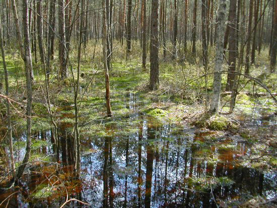
The deciduous and mixed deciduous forests have been decimated, primarily due to the fact that that they used to occur on habitats suitable for agriculture. That refers especially to the lowland mixed deciduous forests (Quercus robur-Carpinus betulus-Tilia cordata), which now cover less than 10% of their original range. Mixed deciduous forests in the western part of the region (Germany, Czech Republic, W Poland) contain an admixture of European beech (Fagus sylvatica), or even small pure beech stands. In the north-eastern part of the region (Lithuania, Belarus, NE Poland) Norway spruce (Picea abies) occurs as an admixture in mixed deciduous stands on fertile habitats, often as a canopy emergent. This is especially pronounced in the Bialowieza Forest, where the old-growth spruces in good habitats can exceed the height of 50 m, they are the tallest trees in North European lowlands. Waterlogged sites are dominated by black alder (Alnus glutinosa), and to a lesser extent by downy birch (Betula pubescens) and various species of willows (Salix spp.). The former poplar (Populus sp.) and elm (Ulmus laevis) forests on river terraces has been largely replaced by willow (especially Salix purpuraea) thickets.Of particular note in the region is the ecosystem of the Białowieza forest (a UNESCO World Heritage Site) located just in the middle of the ecoregion on the border between Poland and Belarus:
one of the largest and definitely the best preserved forest tract in the lowlands of Europe. It still contains a wide array of old-growth forest stands representing all the major habitat types, a rich variety of wildlife and a still not sufficiently studied numerous lower plants, fungi and slime moulds. One of the most distinct features of the ecoregion is the presence of extensive wetland habitats. Common in early mediaeval times, they have since largely disappeared because of intensive draining of marshes and river valleys.
Despite the extensive post-Medieval clearance, semi-natural habitats (like extensively used meadows and traditional pastures) still support important plant and animal communities that include many of the original faunal inhabitants. That diversity is now largely threatened by the changes in land use pattern, namely by more intense management in some areas, and abandonment of traditional management (associated with secondary succession) in others. The forest cover in the entire region is now slowly increasing at the expense of arable land.
However, some of the forest habitats have been dramatically reduced and altered. This refers especially to the riparian forests on river terraces, which have been mostly wiped out and replaced by meadows, pastures or willow plantations. The remaining riparian forests are prone to biological invasions, and their ground vegetation layer is now dominated by a few very expansive alien plants. Also mixed deciduous oak-hornbeam forests have been reduced to a tiny fraction of their original distribution range. [...] Two complexes of marshes, peat-bogs and fens – the Polesie region on the border between Belarus and Ukraine, and the Biebrza valley in the NE Poland – are now among the largest remaining tracts of semi-natural wetlands in Europe. They provide habitat for numerous rare and endangered species, especially birds. The Biebrza valley is now protected within a national park (the largest one in Poland), while the wetlands of the Polesie region are, for the most part, not protected in any way.These forests supported a wider faunal range than today. The largest grazing anuimal was the European bison (Bison bonasus) now only present in a few reserves such as Bialowieza Forest. Wolves (Canis lupus) and bears inhabited the forests in the past, other carnivores included the lynx (Lynx lynx) and some eagles (such as the white-tailed eagle (Haliaeetus albicilla) and the greater spotted eagle (Aquila clanga)). All these are now threatened species, as is the Black grouse (Tetrao urogallus), the largest European woodland grouse.
Source:World Wildlife Fund, 'Central European mixed forests', August 23, 2008
See also: Mixed and Deciduous Forests of the East European Plain
Friday, December 21, 2012
East European Forest Steppe (7)
.
 |
| The forest steppe is the area marked '11' here |
The East European Forest steppe extends from the eastern foothills of the Carpathians in Romania in the west to the Ural Mountains in the east. It forms a series of transition ecoregions between the temperate broadleaf and temperate mixed forests and grasslands biomes (the Central European and Sarmatic mixed forests to the north and the Pontic-Caspian steppe to the south). On the Middle Volga and in the Southern Urals, the strip of forest is about 150 kilometers in width. The zone comprises a combination of forest and grassland sites, and includes areas characterized by the highest biodiversity within the deciduous forest zone of Northern Eurasia.
The composition of deciduous forests changes notably across the region. In the western regions and the European part of Russia, Central European deciduous species occur. In the westernmost areas (the Carpathian foothills and lower slopes), Beech (Fagus) stands with a small admixture of Sycamore Maple (Acer pseudoplatanus), Oak (Quercus petraea), and Lime (Tilia tomentosa) occur. Lime is less common in the habitat than in the past, this due to athropogenic changes (cattle grazing and fibre production). These forests have thick litter, supporting shade-enduring plants, but an almost complete absence of undergrowth. The herbaceous cover is represented only by nemoral species.
 |
Beech forest in Carpathian Mountain foothills (Encyclopedia of Ukraine). |
According to the Encyclopedia of the Ukraine:
A warm summer and a moderately cold winter are characteristic of the forest-steppe. The climate becomes more continental towards the east; the average July temperature is 18°C in the west and 20°C in the east, while the average January temperatures are –4°C and –8°C. The number of days above 0°C is 230 in the northeast and 270 in the southwest. The number of days above 5°C is 190 and 220. Annual precipitation is usually 450–550 mm in the east and 550–700 mm in the west. Eighty percent of the precipitation falls when the temperature is above 0°C. In the summer the rain comes in downpours. The main soils of the belt are deep chernozems and high-humus chernozems (particularly in the southern regions), some of which have been degraded into podzolized and meadow chernozems and gray podzol soils under the influence of forests.
 |
A forest in Ukraine's forest-steppe region (Encyclopedia of Ukraine). |
 |
A forest-steppe landscape in Poltava oblast (Encyclopedia of Ukraine) |
 |
| Velikoanadolskiy Forest on Donetsk steppe - not actually forest steppe per se (Ukraine Adorable Land) |
 |
| Velikoanadolskiy Forest on Donetsk steppe - not actually forest steppe per se (Ukraine Adorable Land) |
The fauna of this zone comprises a mixture of forest and steppe species: forest martens, squirrels, dormice, occasionally encountered are elk, deer, ground squirrels, jerboa (earth hare), marmots, steppe polecat, bustard, little bustard, in the rivers - the beaver and muskrat.
Sources:
Rusnature.info,'Mixed and Deciduous Forests of the East European Plain'.
Volodymyr Kubijovyč, 'Forest-steppe' Encyclopedia of Ukraine, vol. 1 (1984)
Google map.
Thursday, December 20, 2012
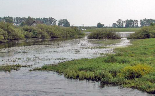
Pripet Marshes (8)
 |
| Within red line - the Marshes along the Pripet (author, schematic) |
 |
| Polesie (Wikipedia) |
The landscape consists of dense woods, interspersed with numerous swamps, moors, ponds and streams . The marshes undergo substantial changes in size during the year, with melting snows in springtime and autumn rainfall causing extensive flooding as the river overflows. Drainage of the eastern portion began in 1870, and significant areas have been cleared for pasture and farmland, much of this in reclamation from the 1960s to the 1980s which has harmed the environment along the course of the Pripyat.
In the tree cover, there is a relatively low degree of deciduousness. Mixed and deciduous forests as well as pure Pinus stands (known as bor in Slavic languages) occur here, the latter mostly on the sandy substrata, intermingling with raised Sphagnum bogs. In the rare drier localities on loamy substrata and more fertile soils, deciduous forests and Quercus-Pinus forests occur.
 |
| Pripyat Marshes (The Ramsar Convention on Wetlands). |
 |
| Pripet marshes, a painting by Ivan Shishkin (1831–1898) (Wikipedia) |
 |
| Polesye Landscape 1884, by Ivan Shishkin (Wikipedia) |
A website with more photos of the watery landscape - Polesia Czar
Part of this landscape extends into Poland, celebrated in a photographic exhibition "W niezwykłym świecie bagien i jezior Polesia Lubelskiego"
Article about the threat to the natural environment (in Polish) 'Torfowiska Polesia – czy grozi nam kolejna katastrofa?'
Wednesday, December 19, 2012
The Steppes (9)
In general, the Early Slavs (500-700 AD) of central and eastern Europe were active only on the margins of the extensive grasslands of the steppes,extending from Hungary to Mongolia. but they interacted with people more at home here like the Avars and Bulgars.

From: 'Archaeology of the Eurasian Steppes and Mongolia' (Annual Review of Anthropology vol. 39).
The precise margins of the steppes in the area of interest here are difficult to define, merging as they do with the forest steppe on the northwest. They also varied with climate change in the centuries under consideration. I wanted to find a map which shows the steppes as extending into the Carpathian Basin which is how Huns, Avars and bulgars moving west ended up in the latter area:
 |
|
Parts of the Ukrainian steppe which are now returning to
nature (Mott MacDonald) |
 |
| Parts of the Ukrainian steppe which are now returning to
nature (Mott MacDonald) |
 |
| Stone 'baba' (cult statue) in Ukrainian steppe grassland (Homutovo) |
 |
| Ukrainian Steppe (Alex Goridko) |
 |
Askania-Nova Biosphere Reserve: the steppe (Encyclopedia of the Ukraine). |
 |
The Black Sea Biosphere Reserve (Encyclopedia of the Ukraine). |
 |
Steppe in Zaporizhia oblast (Encyclopedia of the Ukraine). |
 |
Striletskyi Steppe (Encyclopedia of the Ukraine). |
 |
| Mongolian steppe with yurts (Bruno Morandi -age fotostock/Imagestate) |
See also: Biomes and Regions of Northern Eurasia: Steppe and Forest-steppe
Pontic steppe - Globalspecies.org Google map
Carpathian Montane Forests (10)
 |
| Carpathian montane conifer forests (C Michael Hogan) |
The mountains form a specific ecoregion characterised by diverse geology, soils, vegetation, and anthropogenic impacts. The forest vegetation of the Sudety and Carpathian Mountains form three elevational zones, there are montane to altimontane beech and mixed beech forests, submontane to altimontane spruce and spruce-fir forests, and supporting alpine vegetation. A long period of exploitive economic activity has changed the species composition of mountain forests. Spruce has increased considerably in recent centuries, and the percentage of fir and beech has decreased significantly.
Forests occur in the foothills (as high as about 600 m a.s.l.). These are mostly mixed deciduous forests, which are dominated in the north by pedunculate oak (Quercus robur), lime (Tilia cordata) and hornbean (Carpinus betulus). In the south the forests of this ecozone are dominated by various oak species (Quercus sessilis, Q. cerris, Q. pubescens, Q. frainetto).
Further up the slopes, as Hogan says:
The montane zone, between 600 and 1100 m in the north and between 650 and 1450 m in the south, is dominated by two major species: European beech (Fagus sylvatica) and silver fir (Abies alba). Nearly pure beech forests dominate the montane zone in some mountain ranges in the Western Carpathians (Bile Karpatý, Male Karpatý), the Eastern Carpathians (Vihorlat, Bukovské Vrchý, Bieszczady) and the Southern Carpathians. In most areas beech is mixed with silver fir, Norway spruce (Picea abies), and sycamore (Acer pseudoplatanus). In some places the montane zone is dominated by conifers, usually a mixture of silver fir and Norway spruce (Tatras, Moravske Beskydy, Oravska Magura in the Western Carpathians, Gorgany, Czornohora, and Munti Bistrei in the Eastern Carpathians).Higher still the montane forests at sub-alpine altitudes on mountains have a character rather like that Boreal coniferous forest of the taiga. The dominant species are coniferous trees, especially species of fir, larch, pine, and spruce (though some broad-leaved angiosperm species, especially aspen, birch, poplar, and willow also grow):
The subalpine zone (1100-1400 m in the north, 1400-1900 m in the south) consists of almost pure Norway spruce forests, with a small admixture of rowan (Sorbus aucuparia). Stone pine (Pinus cembra) occurs at the alpine timberline in the highest mountain ranges (Tatras, Czornohora, Marmures, Fagaras, Retezat) of the Carpathians. At the timberline belt of the Tatras mixed Pinus cembra-Larix decidua forests grow, similar those in central Alps. [...] The Bieszczady mountains in the Eastern Carpathians lack the subalpine spruce forest zone. Here, the timberline of dwarfed beeches (at approximately 1200 meters) directly border the alpine meadows.
 |
| Southern Carpathian Mountains, Romania. (C.Michael Hogan) |
The Carpathian Mountains are still the habitat for the European bison, brown bear, wolf, lynx, wild cat, and a nesting site of the golden eagle.
 |
| Juniper forest Ukrainian Carpathians (Encyclpedia of the Ukraine) |
 |
| Spruce Forest Ukrainian Carpathians (Encyclopedia of the Ukraine) |
The montane forests of the of the Carpathians were not generally settled by the Slavic-speaking communities until quite late on.
An important process for the development of the entire region was the movement of the Walachian shepherds from the Balkans along the entire Carpathian chain in the Middle Ages. The Walachians were the first people to inhabit the more remote areas in the interior of the mountains. By cutting and burning forests along the mountain ridges they created numerous glades and meadows, which since have been a distinct feature of the Carpathian landscape. Traditional forms of grazing cattle, sheep and horses still persist in the Southern and Eastern Carpathians in Romania and in Ukraine, but are rapidly declining in the Western Carpathians.They arrived in Poland in the thirteenth century, and it is from this time that the distinctive Highlander folk culture developed in the region.
Sources: C Michael Hogan, 'Carpathian montane conifer forests', The Encyclopedia of the Earth World Wildlife Fund August 23, 2008
Tuesday, December 18, 2012
Alpine vegetation zone (11)
 |
| The Alps - Wikipedia |
The Alps, a very high mountain range some 200 km across, extend in an 800 km (500 mi) arc from France in the south and west to Slovenia in the east, and from Monaco in the south to Germany in the north. The peaks in the easterly portion of the range, in Austria and Slovenia, are lower than those in the central and western portions.
The natural habitats range from meadows, bogs, woodland (deciduous and coniferous) areas to soilless scree and moraines, and rock faces and ridges. The chief deciduous trees of the region are oak, beech, ash and sycamore maple. Human interference has nearly exterminated the trees in many areas, and, except for the beech forests of the Austrian Alps, forests of deciduous trees are rarely found after the extreme deforestation between the 17th and 19th centuries.
 |
| Alps with modern borders (Wikipedia) |
 |
| Naturpark Zillertal |
 |
| Naturpark, Zillertal |
Monday, December 17, 2012
Pannonian mixed forests (12)

Subscribe to:
Posts (Atom)